

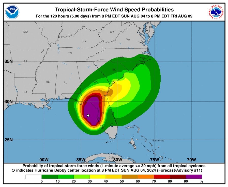
Hurricane Debby made landfall along Florida’s Big Bend coast on Monday morning, and has since left at least five dead across Florida and Georgia as parts of Southeastern US face catastrophic conditions.
The National Hurricane Center (NHC) announced that the storm came ashore near the coastal town of Steinhatchee in Taylor County, Florida, at approximately 7am ET on Monday with maximum sustained winds of 80mph.
Debby was strengthened to a Category 1 storm on Monday morning as it churned through the Sunshine State, before later being downgraded back to a tropical storm. More than 16 inches on rain were dumped on parts of central Florida.
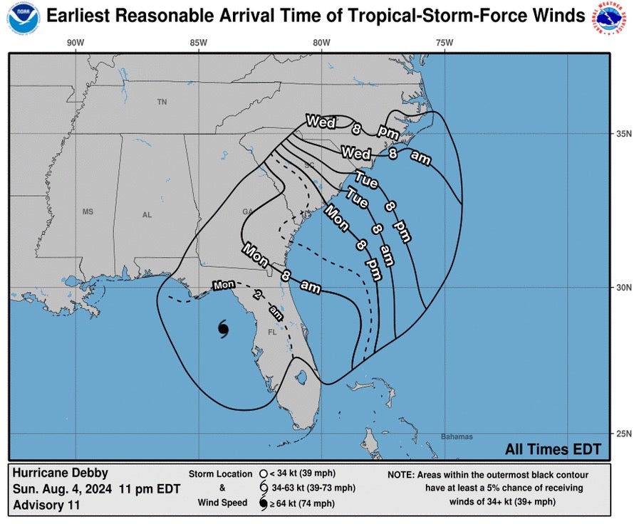
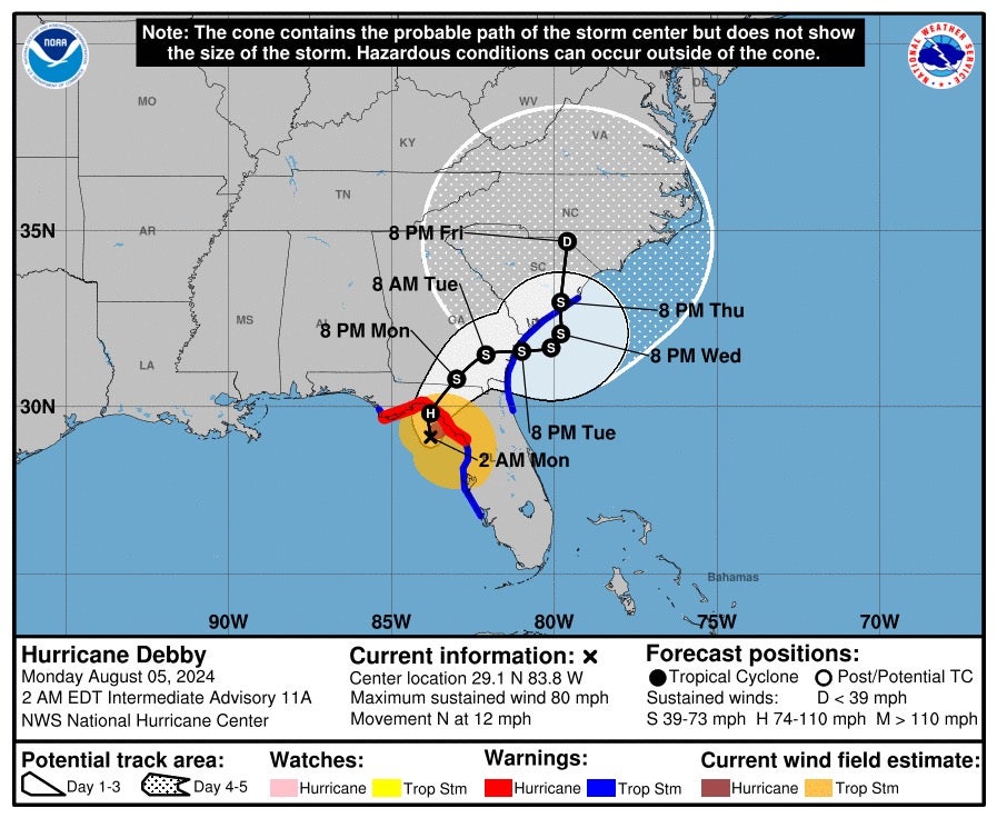
Debby pushed slowly north-northeast through the Sunshine State at 10mph. It approached the Florida-Georgia border late on Monday evening, and is expected to drift towards coastal Georgia and South Carolina throughout the week.
The storm may move off the Southeast coast and into the Atlantic Ocean by late Tuesday where it is expected to meander for 24 hours before turning back towards the coast by Thursday.
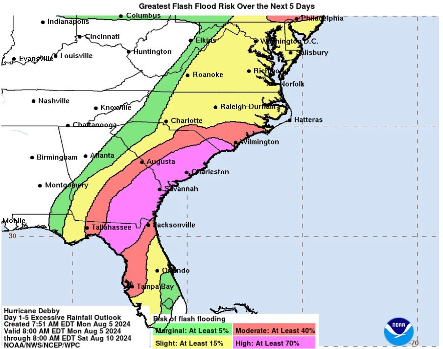
The director of NHC Jamie Rhome told the BBC that the storm will cause “catastrophic flooding”.
The National Weather Service (NWS) also gave a tornado watch update, which predicted almost 11.7 million Florida and Georgia residents could be exposed to tornadoes – ranging from Sarasota, Florida, to Savannah, Georgia.
A twister ravaged through Edisto Island, South Carolina, late on Monday, leaving homes with significant damage.
At least five people have died due to the torrential conditions including two 12-year-olds and a 13-year-old.
More than 350,000 residents and businesses were left without power during peak outage across Florida, according to PowerOutage.us – with the counties of Taylor, Madison and Jefferson hit the hardest.
Florida Governor Ron DeSantis said some 17,000 linemen are working to restore electricity.
Debby grew in strength overnight in the warm waters of the Gulf of Mexico, building from a tropical storm to a hurricane.
DeSantis declared a state of emergency on Sunday and warned residents to “make sure you’re executing your plan now”.
He has also warned citizens not to “tempt fate” by driving in torrential conditions over the risk of “traffic fatalities,” he said in a Monday morning briefing.
Over the weekend, Florida residents had begun to hunker down for the storm, boarding up their windows and evacuating homes in storm surge evacuation zones.
Dangerous winds are forecast to drift inland towards Georgia, South Carolina, and parts of North Carolina from Monday through Wednesday before the storm dissipates at the South-North Carolina border at around 8pm Friday.
Georgia Governor Brian Kemp and South Carolina Governor Henry McMaster also issued emergency declarations for their states.
Once over the Atlantic, Debby is not expected to regain hurricane strength, meaning South Carolina, Georgia, and parts of Florida’s northeastern coasts are under tropical storm rather than hurricane warnings.
However, NHC director Dr Michael Brennan said the storm slowing down over land could “exacerbate not just the rainfall risk but also the potential for storm surge and some strong winds”.
")


